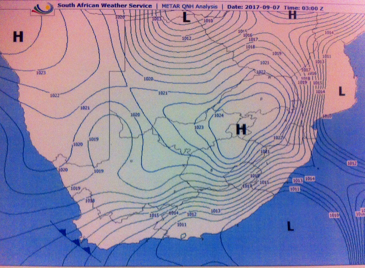
When starting flying lessons, we are given a lot of sound advice, but over time, especially if you don’t fly longer cross country trips on a regular basis, the warnings become faded and are sometimes forgotten. One of these wicked phrases that we were all taught is ‘High to low, careful go!’, but understanding what this means can be a challenge.
Let’s start with the ‘High’ and the ‘Low’. These refer to pressures, but temperature, and humidity also play a part. Caution is needed when we are flying to an area of high pressure to an area of low pressure. For example, when we plan a flight from Johannesburg to Durban, we can expect a significant change in pressure.
The theory is that the higher the altitude, the lower the pressure. The lower the altitude, the higher the pressure. The amount of air over Johannesburg, it is much less than the amount of air over Durban as it is higher up in altitude than Durban. So, if we do not change our altimeter setting from a high QNH to a lower one, then we will in fact be flying LOWER than what is indicated (30 x the difference between the QNH’s). Looking outside will probably tell you that something is not quite right and that you are flying a bit too low for comfort. This is DANGEROUS!
It is important to remember that when you obtain a QNH for your departure aerodrome, that this is barometric pressure corrected for MSL (Mean Sea Level). Your altimeter, is calibrated using ISA (International Standard Atmosphere), so it will only indicate altitude correctly at the airfield reference point. From here on, if there is a significant change in pressure altitude, you will need to reset the altimeter with the correct pressure setting for the area over which you are flying, to ensure a correct reference, unless you are flying the flight level setting standard which is ISA 1013 (QNE).
You may be thinking that our QNH chart is confusing – if the pressure over Johannesburg is supposed to be lower because of its altitude (+_1600m above sea level),, then why does the chart indicate that in fact the high pressure (and higher QNH value) exists over Johannesburg and not Durban? This can be explained as follows:
As we can see from this QNH chart (which you can easily obtain from aviation weather), a high pressure dominates over Gauteng, and the QNH is 1024. if we look at the East coast, the QNH is much lower, between 1011 and 1013. This is indeed not what we would expect based on altitude. The reason for this is that temperature and humidity are also related. If you are flying from a warm and humid area, (as air heats up, molecules expand outwards and are less densely ‘packed’, which means pressure decreases) to a cold dry one (where air molecules are tightly ‘packed’, and therefore pressure increases) you will see this phenomenon.
Avoiding all this is relatively easy:
– Check the QNH chart before you depart so that you know what to expect.
– If you are not sure of what your altimeter setting should be, ask ATC or the relevant Flight Information Service.
– Look outside – if it looks wrong, then check!
– FREDAS – by doing these you will be ensuring that you have indeed changed the altimeter setting.


